Where Are the Gaps in Your Transit System?
Where should your city aim to add transit service? The places where more buses and trains will be most useful are areas where lots of people live or work, but there’s not enough service to meet the demand.
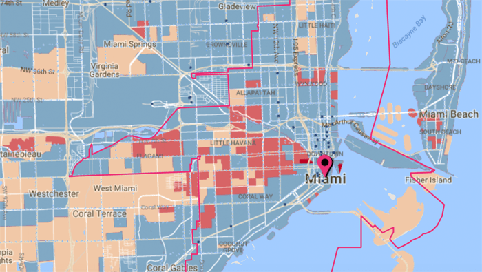
A new data tool from the Center for Neighborhood Technology helps pinpoint these locations in cities around the U.S. The “Gap Finder” — an extension of CNT’s All Transit database — overlays demographic data and transit schedule information on maps that highlight where more people would ride transit if service levels were higher.
The transit gaps mapped by CNT are not to be confused with “transit deserts” — areas with no transit at all. Areas with some transit service may still not have nearly enough to adequately serve the people who live or work there, while areas without any service may be so spread out that fixed-route transit won’t do much good.
“The goal is to understand where transit need is being met” and where it’s not, said Zak Accuardi of TransitCenter, which funded CNT’s work.
These gaps in service are highlighted in red on CNT’s map, and areas where transit service is aligned with current demand are in blue. Other areas are too suburban or rural for fixed-route transit services to work well.
Some transit gaps reflect the high concentration of people and jobs in relation to transit service levels. That’s the case in Hoboken and Jersey City, the cities directly across the Hudson River from Lower Manhattan.
“These are neighborhoods that are super dense,” said Accuardi. “It’s basically like brownstones. There’s also a lot of jobs in both Hoboken and Jersey City. The volume of transit service that folks there have access to is pretty good compared to the rest of the country. There’s a lot of bus routes operated largely by New Jersey Transit there. For most people in those areas, it’s still really not enough.”
CNT quantifies the share of each city’s population living in neighborhoods without adequate transit service. About 42 percent of Miami residents live in areas that qualify as transit gaps, for instance, while in Houston the figure is 55 percent:
The transit gap tool is intended to help local advocates and policy makers think through how they want to improve service. Red areas on the maps should stand out as candidates for increasing the frequency of train and bus service.
For a few reasons, though, the maps shouldn’t be viewed as the last word in assessing transit needs, Accuardi says.
The transit data the maps are based on comes from posted schedules, not real time data. So routes where agencies run a lot of buses but service is slow or unreliable because of traffic congestion won’t get flagged, for instance. Nor do the maps account for barriers to walkability like highways that may make dense areas appear more well-suited for transit than they really are.
“The tool helps to identify areas that are of interest,” said Accuardi. If you want to know where adding bus or train service will help the most people, mapping the transit gaps is an excellent starting point.

Read More:
Streetsblog has migrated to a new comment system. New commenters can register directly in the comments section of any article. Returning commenters: your previous comments and display name have been preserved, but you'll need to reclaim your account by clicking "Forgot your password?" on the sign-in form, entering your email, and following the verification link to set a new password — this is required because passwords could not be carried over during the migration. For questions, contact tips@streetsblog.org.