Tracking the Great Streets program as it has begun to unfold around town has, at times, been a bit of an exercise in frustration. Which never fails to strike me as odd, given Mayor Eric Garcetti's declaration that the transformation of the 15 chosen streets into gathering places would happen via a "bottom-up and community-based process" in which the city "[worked] with neighborhood stakeholders to develop a vision for each corridor."
But the incredibly robust public engagement process seen in Mar Vista -- one in which the district's very enthusiastic City Councilmember Mike Bonin used the plans as an opportunity to engage his constituents about how Venice Blvd. could be re-imagined, the neighborhood council created a Great Streets ad hoc committee, and community members were asked their opinion on a variety of potential improvements -- has yet to be replicated elsewhere. [See the kinds of options offered to Mar Vista residents on everything from bikeways to crosswalks to bus amenities to street furniture to events/programming, below.]
Instead, the experience in other districts has been decidedly more uneven.
Along Central Avenue (South L.A.), there was practically no outreach early on; when outreach did finally get underway, it was to let folks know what had already been decided upon for their street, not to solicit their ideas on the options for how to transform the area.
The selection of N. Figueroa (Highland Park) as a Great Street seemed to give Councilmember Gil Cedillo the opening he was looking for to re-route the bike lane planned for the corridor, regardless of what some in the community wanted (and possibly inspiring Councilmember Curren Price to do the same for the bike lane planned for Central Ave.)
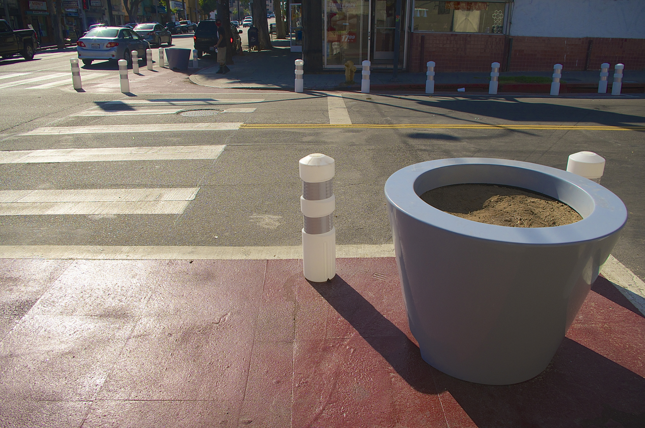
And along Cesar Chavez Ave. in Boyle Heights, curb extensions were first striped at St. Louis in early June -- well before the neighborhood council was approached about what was happening in their neighborhood.
The wider community was also only introduced to the plans during a few outreach sessions -- one on the corner where installation of the bulb-outs had already begun in late June and at a couple of open houses held in mid-August, long after installation was complete and work was already underway at another intersection on the street.
When asked about the discrepancy in the processes, the mayor's office responded via email that, "The work on Cesar Chavez was focused on pedestrian safety improvements and was accomplished through a partnership between LADOT [the L.A. Department of Transportation], Councilmember Huizar, and the Great Streets Studio. These kinds of basic improvements, similar to filling a pothole or fixing a sidewalk, may be made on a Great Street segment separately from the visioning process with the community."
The launch of Vision Zero (the directive to reduce traffic deaths to zero by the year 2025), the email continued, provided an opportunity to "quickly design and deliver a series of improvements" along the street in the vein of the original Cesar Chavez Streetscape Project in about three months' time.
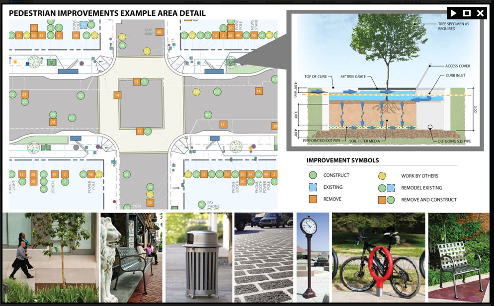
That streetscape project, first conceived in 2008, was intended to offer a comprehensive transformation for the corridor via the repair of broken sidewalks, enhanced pedestrian facilities (including curb extensions, crosswalks, street furniture, and pedestrian lighting), improved transit facilities (i.e. bus stop lighting), improved connections between Cesar Chavez and key points in the community (the Gold Line, schools, and shopping/dining), new trees, better stormwater management, better landscaping, historic signage, and the undergrounding of utility lines.
Those improvements (including the curb extensions, below) and others that were part of the Adelante Eastside Redevelopment Project (i.e. façade improvements, affordable housing projects) were put on hold, thanks to the dissolution of the CRA in 2012, and the money for the street improvements was divided up among several City departments.
LADOT now serves as the lead agency on Cesar Chavez, and looks to begin implementing $5.6 million worth of sidewalk improvements in 2017, when Metro should begin to disburse its share of the funds for the project.
To facilitate that process, the City plans to do design and outreach (and possibly construction) around the project before 2017, using its local match funds to get started. That project will also extend beyond the boundaries of the Great Streets segment of the avenue, meaning that, from Warren (just west of White Memorial) to Lorena, Cesar Chavez will see fixed sidewalks, bus stop lighting, crosswalk improvements, curb ramps, benches, trash cans, and new trees.
All of which is fantastic to hear -- residents and shop owners in this lower-income and heavily pedestrian-, bike-, and transit-dependent community have long been asking for their sidewalks to be fixed and their streets to be safer. These are certainly complaints I've been hearing for years.
But it did leave me with questions about what Great Streets' own plans for Cesar Chavez were, independent of these other improvements that have long been on the table. Will there be, for example, a real investment in redesigning the intersection at Soto? The changes along Cesar Chavez and the speed with which they have been designed and implemented were linked to Vision Zero -- a safety-specific policy. Yet the most problematic intersection -- and most important, with regard to transit and connectivity -- is receiving the least in upgrades. And it isn't clear where the plans for the street fit into the Mobility Plan's plans for the street, which mark it for peak-hour bus-only lanes (which tend to run curbside and would thus run into the curb extensions) and a bike lane or shared bus/bike lane.
I also wondered how the haphazardness of the engagement process in communities like Boyle Heights would help the city “[lay] the foundation for a long-term funding, design development, management, and implementation strategy to install improvements and recommend policy that activates the public realm and stimulates economic revitalization" or advance some of its broader goals, including increased economic activity, enhanced neighborhood character, or the fostering of greater community engagement.
Enhanced safety is a great start, but it isn't enough to bolster economic growth or neighborhood transformation on its own. And, thus far, there's been little engagement of business owners along what is the community's most prominent commercial corridor, either about the coming changes or their aspirations for what shows up outside their doors. And there has been even less engagement with community members about how treatments to this unique corridor -- either temporary or permanent -- might be more reflective of the culture and character of a historic community.
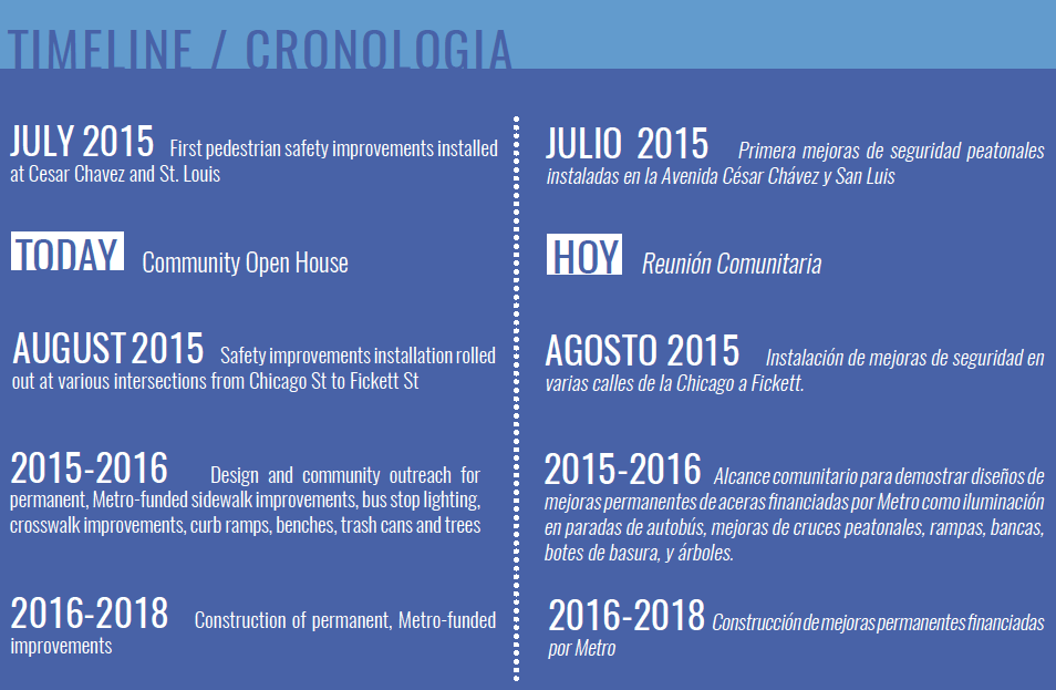
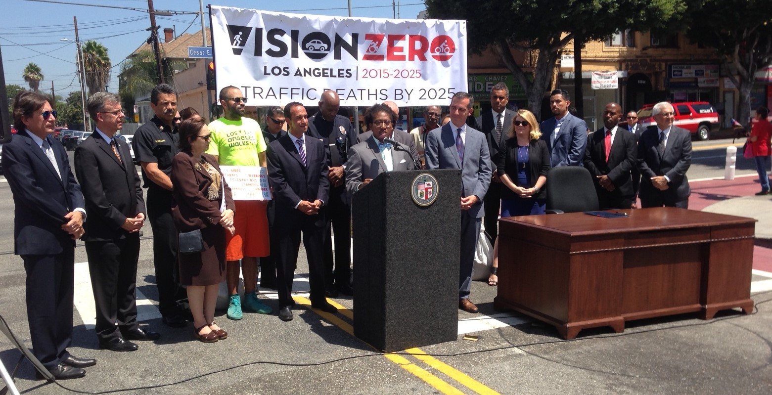
In their response, the mayor's office said that they planned on embarking on a visioning process in coordination with the Council Office and Multicultural Communities for Mobility -- winners of the challenge grant for Cesar Chavez -- with stakeholders to update plans for the avenue. That should happen later this year into next, although no definitive timeline has been set yet (at right).
For now, however, Great Streets' focus seems to be on using Cesar Chavez as a testing ground for how a data-driven approach to implementing Vision Zero might work.
Cesar Chavez has long been treacherous for pedestrians. Under Vision Zero, LADOT plans to conduct studies to track the impact of the improvements on the behavior of pedestrians, cyclists, buses, and private vehicles along the corridor. So, once all of the improvements are completed, data will be gathered from the intersections and analyzed to assess the value of the changes.
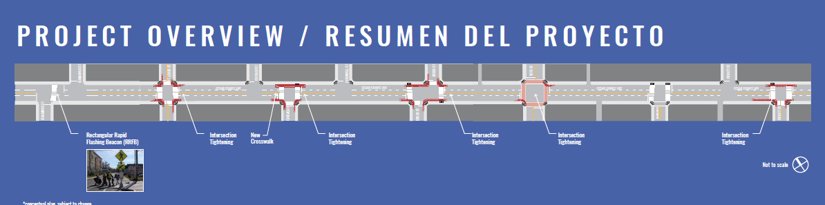
The intersections slated for the first round of improvements include St. Louis, Chicago (south side), Breed, Soto (limited tightening of the intersection at two corners), Mathews (just the crosswalks), and Fickett (south side) [See figure at top of article].
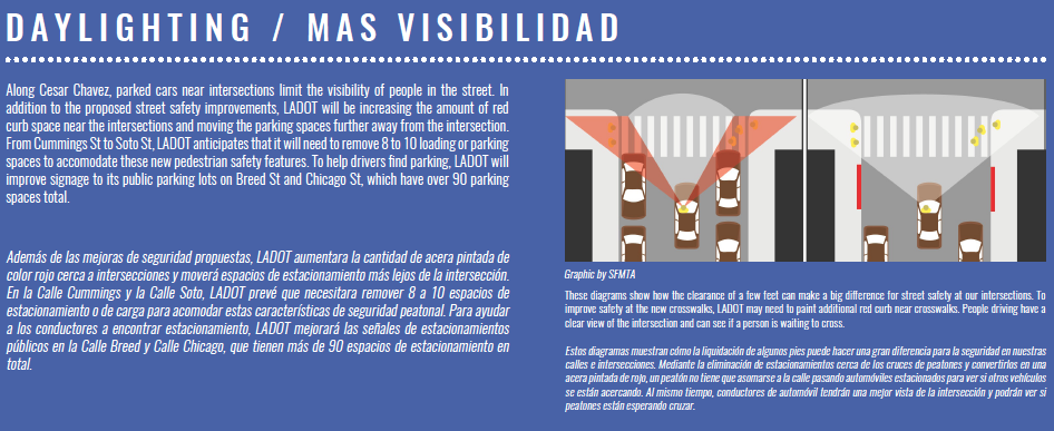
To make the pedestrian zones truly pedestrian-friendly (i.e. improving visibility at crosswalks), Great Streets estimates it will need to remove between eight and ten parking spaces between Cummings and Soto and says it will add wayfinding signage to direct people to the parking lots off Breed and Chicago Streets (below, at left).
Once the data has been gathered and assessed from these sites, the next round of improvements will go in between Soto and Evergreen.
For those that are not fans of the red paint, the white bollards, or the planters, the city wants you to know that those will be converted into permanent curb extensions using actual cement when the rest of the sidewalk improvements go in (2017). The goal now, the city explains, "was to achieve the immediate safety benefits on a very accelerated timeline" and in a cost-effective way, as well as to be able to assess the functionality of the improvements and make any necessary adjustments before they were made permanent.
I do hope that in the effort to assess the data, the city goes beyond some of the data points it is currently looking at to assess the value of its improvements. Below, the number of pedestrians, the number of cyclists, and bus ridership are described as a few of the data points they call out as important. But, given that Boyle Heights is a lower-income community with lower car ownership and greater dependency on transit, walking, and biking, those numbers are unlikely to offer much in the way of insight. Adapting data surveys to the realities of the neighborhood, including using more qualitative queries to capture shifts in perceptions of safety and comfort on the streets, might be a better way to get a fuller picture of the impact of the changes.
It is not clear yet what data will be used to assess the impact of the improvements on some of the broader goals of the Great Streets program.
As of now, no dates have been set for community engagement around the changes along Cesar Chavez. If you'd like to offer up feedback or ask questions regarding the improvements along the avenue, please leave them in the comments below or contact Great Streets via their facebook page, tumblr, or twitter. See the full images of the blue Great Streets boards (posted throughout this article) at their tumblr post, here.