Bus Rapid Transit Plans in SGV Get Clearer, and More Complicated
New concepts for rapid bus service across the 626 have ironed out the questions of where an East-West route would run and where demonstrations could begin.

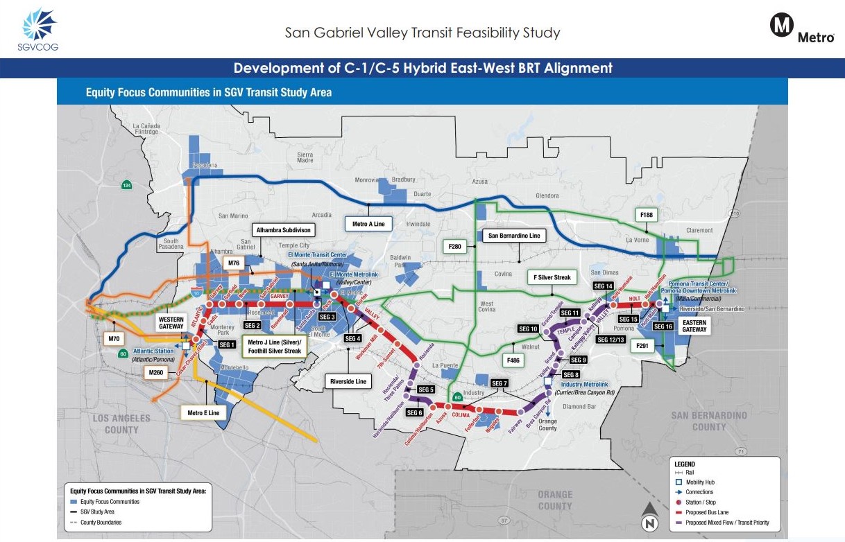
The 2035 Mid Term Horizon plan for Bus Rapid Transit from the San Gabriel Valley Council of Governments.
The San Gabriel Valley Council of Governments and engineering firm Kimley-Horn have released several new concept maps for Bus Rapid Transit (BRT) lines being developed under the COG’s Transit Feasibility Study. The concepts were presented at a pair of public workshops on November 28 and 29.
The study calls for a hybridized approach using a mix of some bus-only lanes (quality actual BRT) and some places where buses still run in mixed-flow lanes with car traffic (not quite BRT). This sort of hybrid is common, but too much watering down can mean few benefits to transit riders.
The BRT lines would also have limited stops, enhanced stations, signal prioritization, and frequent service. These would either be side-running (right of mixed-flow, left of parking) or curb-running (against the curb) rather than center-running.


The main lines that are currently being planned are:
- a North-South route on Rosemead Boulevard
- an East-West route primarily on Valley Boulevard that would run from Union Station to the Pomona Transit Center
There are also several lower priority North-South routes that would not have dedicated lanes. For the most part these facilities would be in the southern San Gabriel Valley in Metro’s Equity-Focused Communities.
BRT funding would come from Metro Measure M, which includes $635.5 million for SGV sub-region transit improvements, originally expected to go to the canceled Metro proposal to extend the E Line train along the 60 Freeway.
The COG’s Manager of Transportation Roy Choi said, “What happened was it was determined that the cost was prohibitive, the environmental impacts were too great, as well as the physical constraints on the Right-of-Way.” Choi added that the study’s proposed concepts “mimic and replicate this loss of services” from the abandoned light rail plan.
East-West
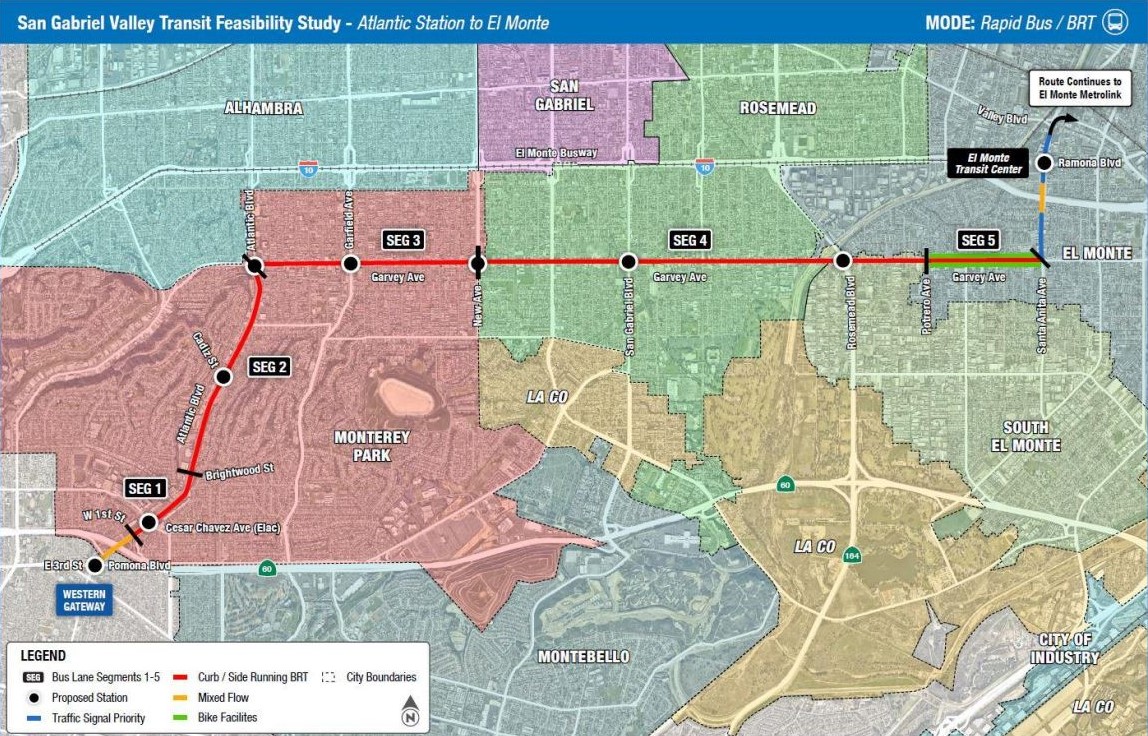
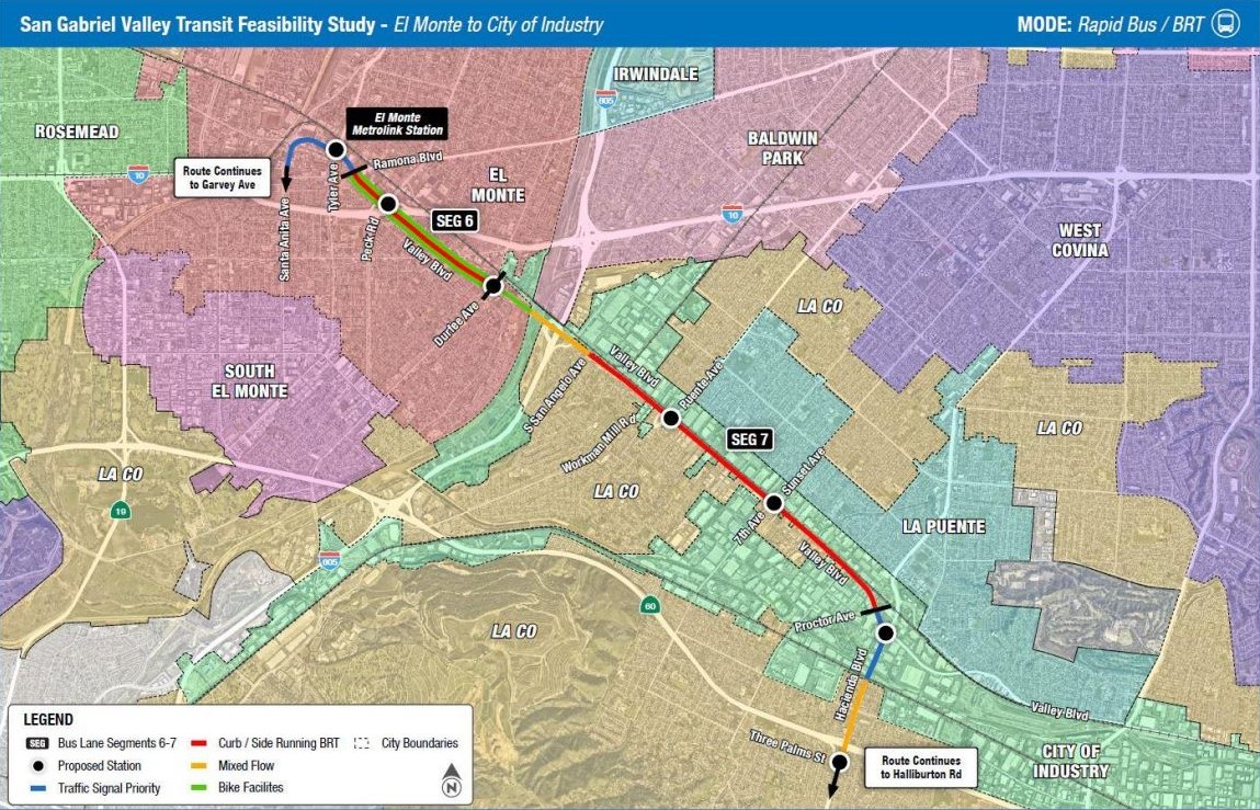
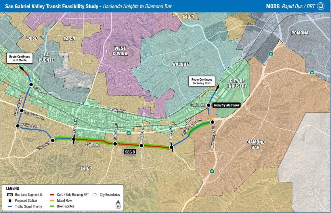
Looking first at the massive East-West line, the plan shows new details for the eastern half of the route, past Hacienda Boulevard and Valley. When SBLA last covered the study a year ago, it was up in the air whether the line would:
1. keep running down Valley to Grand Avenue, and then north up to Mt. San Antonio College and Cal Poly Pomona on Temple Avenue, before terminating on Holt Avenue in Pomona
or:
2. jog south to the mall area on Colima Road (via the shortcut Halliburton Road), and then through Diamond Bar on Golden Springs Drive up to Mission Boulevard in Pomona.
Now, the difference has been split. After Hacienda, the route would go south to Colima, then north to Grand via Brea Canyon Road to link up with Mt. SAC and Cal Poly before taking Holt to the Pomona Transit Center.
It's important to note that west of Santa Anita Avenue, the East-West line wouldn’t have dedicated lanes on Valley owing largely to incompatibility with Alhambra and San Gabriel roadway plans that prioritize driving over transit. Though the plan still marks this section of Valley for “Rapid Bus Priority” with fewer stops, higher speeds, and signal priority.
Kimley-Horn’s Project Manager Brent Ogden said, “With regard to Valley Boulevard in Alhambra, the city indicated to us that the improvements that they're currently planning to implement along Valley Boulevard would preclude the installation of bus lanes in that jurisdiction and we're also told the same thing by the city of San Gabriel.”
“I believe the city [of Alhambra] had concerns with the existing congestion,” added Choi. “Unfortunately, they have to bear the brunt of the 710 where it ends and basically dumps the traffic into the city. So there were concerns that they wanted to make sure that there was enough capacity on the roadways to accommodate general purpose automobiles.”
In the city of San Gabriel, Ogden previously said that Valley Blvd “is being reconfigured to handle higher levels of vehicular traffic. The improvements that are being planned in that area basically preclude bus lane conversion [...] their focus is on moving cars and moving trucks.”
Other areas where the line would not have dedicated lanes include short stretches close to freeway ramps.
Fortunately, the hybrid concept now also includes dedicated bus lanes on Garvey Avenue. These would begin at the Metro E Line Atlantic Station and travel up Atlantic Boulevard to Garvey, and then continue east to the El Monte Transit Center at Santa Anita Avenue, then connecting to the dedicated lanes on Valley.
Traversing the entire 34-mile East-West route is estimated to take about 100 minutes.

North-South
The primary North-South concept on Rosemead is much simpler. Its northern portion, from Valley to the Sierra Madre Villa A Line Station, would run in mixed-flow lanes.
Ogden and Choi both remarked that Temple City had already made a large investment in its protected bike lanes on Rosemead, so re-doing the road there would not be preferable.
Protected bike lanes are compatible, arguably very complimentary, with bus-only lanes. Bus lanes with protected bike lanes are shown in the study images; see Side Running Bus Lane Prototype slide above. There are various examples of this configuration working well in central Los Angeles on Venice Blvd., Grand Ave., Olive St., and 5th and 6th Streets.
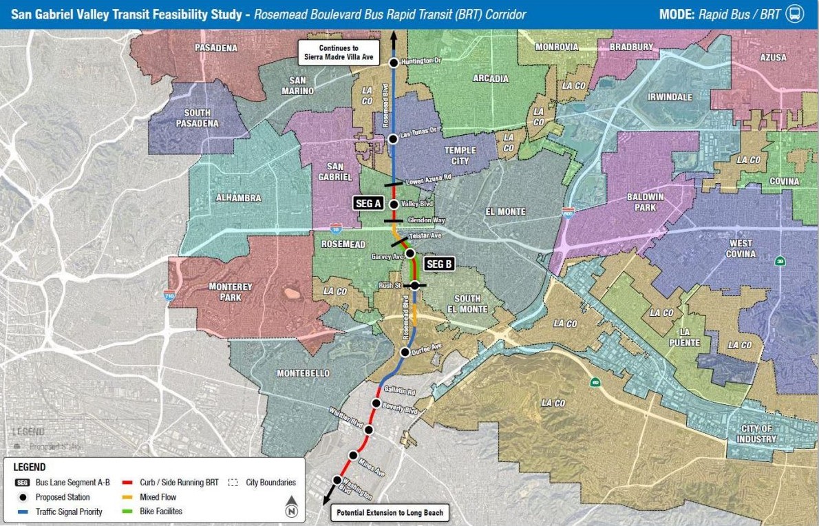
Then a section of dedicated lanes would run through Rosemead and South El Monte, turn back into mixed-flow through unincorporated Los Angeles County, and return to dedicated lanes from Gallatin Road to an end at Washington Boulevard in Pico Rivera.

The revised concept also continues to show five other north-south running “Rapid Bus Priority Corridors” that connect to the East-West line and terminate at Metro A Line Stations near the San Gabriel Mountain foothills. At their south ends, they run to the Gateway Cities, East L.A., and North Orange County. Dedicated lanes aren’t being planned on these routes, which are not projected to have as much ridership as Rosemead Blvd., according to Ogden.
What’s next?
Ogden told members of the public at both workshops that the 2035 Mid Term Horizon Plan would still come in on budget when the money is finally available to pay for the BRT Lines, even adjusting for inflation.

However, Ben Feldman, Special Projects Deputy for County Supervisor Hilda Solis’s office had a more ambitious outlook.
“The funding for this project, as mentioned, multiple times, comes up in 2035. That is not satisfactory for the supervisor,” declared Feldman. “We've been pushing to look at alternative funding sources to bring this earlier, including having parts of the project be included in the Olympics 2028 plan.”
Feldman went on, “If you don't know, there will be no cars for the Olympics, there is no parking, you cannot drive to the games, you will have to take public transportation to participate. And that includes the million plus visitors that might be attending. So preparing for the games is going to be very, very critical. And we see it as essential that the San Gabriel Valley gets its fair share and investments and ensures that our transit dependent riders are able to partake in the general economic growth that comes with these projects.”
Keep in mind, Olympic mountain biking events will take place at Bonelli Park in San Dimas.
If accelerating full funding proves too difficult, many (generally relatively inexpensive) bus improvements could be phased in - especially bus-only lanes. The study identifies six possible locations for "jump start" bus lane demonstrations. See map below.
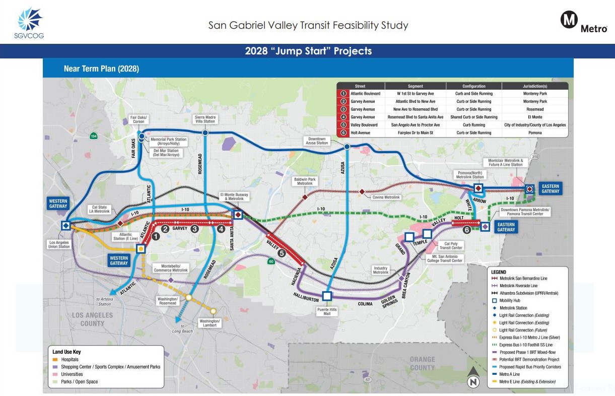
The jump start projects could be quick-build improvements that improve SGV transit fairly soon. Ogden said though the team has reached out to the COG member cities where the demonstrations might be installed, but “we're waiting to hear.”
There has been no decision yet on what agency would operate buses along these future BRT lines, though Choi indicated Foothill Transit will pursue one, “but we will address that as well, in the next phase of the study.”
Public Input
As part of the Transit Feasibility Study, over 400 residents have been surveyed on their transit needs. Of those, 15 percent don’t have access to a car, 20 percent use transit regularly, and 30 percent take transit daily or weekly. Many expressed a desire for safe and affordable public transport, with connections to the SGV’s colleges, and better first/last mile connections.
The public has until December 31 2023 to email comments to roychoi@sgvcog.org.
Streetsblog’s San Gabriel Valley coverage is supported by Foothill Transit, offering car-free travel throughout the San Gabriel Valley with connections to the Gold Line Stations across the Foothills and Commuter Express lines traveling into the heart of downtown L.A. To plan your trip, visit Foothill Transit. “Foothill Transit. Going Good Places.”Sign-up for our SGV Connect Newsletter, coming to your inbox on Fridays!
Stay in touch
Sign up for our free newsletter
More from Streetsblog Los Angeles
LAPD Was Crossing Against Red Light in Crash that Killed Pedestrian and Injured Six in Hollywood
The department says the officers had turned on their lights and sirens just before crossing, but won't say why they did so.

Freeway Drivers Keep Slamming into Bridge Railing in Griffith Park
Drivers keep smashing the Riverside Drive Bridge railing - plus a few other Griffith Park bike/walk updates