Glendale-Hyperion Bridge Traffic Projections Favor Bike Lanes Option
As the saga of the Glendale-Hyperion Bridge retrofit project continues, it becomes clearer that, even under the city's car traffic growth assumptions, it will be viable to add bike lanes to the new project and to keep two sidewalks.
The story thus far: In 1927 the City of Los Angeles completed the Victory Memorial Viaduct spanning the not-yet-concreted Los Angeles River. The historic bridge is, today, better known as the Glendale-Hyperion Bridge, because it facilitates the merging of Glendale Boulevard and Hyperion Avenue.
Over a decade ago, funding became available for bridge retrofit projects. Glendale-Hyperion was just too lucrative for bridge consultants to pass up. The historic viaduct is technically a six-bridge complex, so it is eligible for six times more money than an ordinary bridge. In 2013, city staff and their consultants pressed for a wrongheadedly dangerously high-speed highway-scale design. Cyclists, pedestrians, and local leaders organized visible vocal opposition to the city's proposal. What had looked like a done deal began to appear shaky.
To its credit, the city responded by forming a Citizens Advisory Committee. Earlier this year, the city returned to the committee with multi-modal design options, including bike lanes, sidewalks, and crosswalks.
In a recent presentation [PDF] to the advisory committee, the city showed the results of its technical studies analyzing how various potential bridge configurations can be expected to perform.
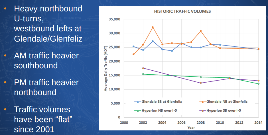
The graph above shows past car traffic volumes measured on the bridge.
Even according to the city's characterization, "traffic volumes have been flat since 2001." During this period, nationwide per capita car mileage declined. Nationwide overall total car miles driven also declined. Locally, car traffic on the Hyperion portion of the bridge, the lower green and purple lines on the above graph, also declined. But call it flat for now.
The city's experts used "historic data" and other factors to predict the bridge's car traffic in 2040. With car traffic flat for over a decade, one might assume that future car volumes would continue their observed flat trajectory. No. The city's fortune tellers predict a worst-case scenario showing 1 percent annual growth. Apparently, in the 2030s, people are going to drive like they did in the 1980s. As transit planner Jarrett Walker states, "This isn't prediction or projection. This is denial."
These sorts of predictions generally justify widening roadways which squeezes out space for pedestrians and cyclists.
The city ran its car traffic prediction models. Models based on "Level of Service," in which the words "safety," "walk," and "bicycle" do not appear. LOS models keep predicting that widening freeways will reduce surface street traffic and improve air quality. Though the State of California is in the process abandoning LOS, it remains in wide use.
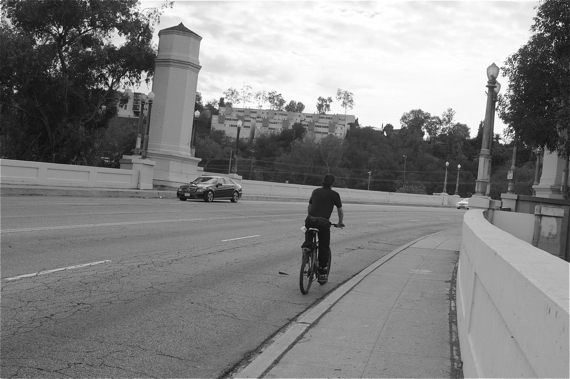
Even with an imaginary 1 percent annual car traffic growth for the next 25 years, a 3-lane road diet option performs slightly better than all other scenarios studied, including the bridge's current 4-lane configuration. Right now on Hyperion, there are four car lanes, two in each direction. A road diet would eliminate one southbound northbound car lane, and add bike lanes.
The city calculated a "System Delay Per Vehicle" that purports to quantify overall average delays to all drivers using the bridge during periods of peak usage. The driver delay measured under current conditions is 41 seconds. The city predicted 2040 delays under five different scenarios:
- 3 car lanes, 2 bike lanes, without a crosswalk over Hyperion: 102 seconds total delay
- 4 car lanes, without a crosswalk over Hyperion: 104 seconds total delay
- No build (existing conditions): 116 seconds total delay (similar to the above scenario, this is 4 car lanes, without a crosswalk, but doesn't include other project features, including re-configuring a 5 Freeway offramp)
- 4 car lanes, with a crosswalk over Hyperion: 125 seconds total delay
- 3 car lanes, 2 bike lanes, with a crosswalk over Hyperion: 130 seconds total delay
It is not uncommon that a "road diet" lane reduction project results in overall decreased delays to drivers. Road diets can facilitate turns, and reduce conflicts and collisions; this can result in smoother car traffic flow, even without increasing speeds. What is uncommon is for traffic projection models to actually predict better driver outcomes with reduced driver lanes.
A city staffer, who declined to be named for this article, suggested that the lane reduction option performing best might be analogous to meters on freeway on-ramps. The ramp meter delays individual drivers slightly, but may make the car traffic flow more regular and thus result in less overall delay.
Solely on the criteria of delays to drivers, the city's own analysis predicts that a 3-car-lane configuration will work best. SBLA is not recommending that any project should ever be studied solely with regard to driver delay, but that is what the city has done here. The overall difference is only 28 seconds peak delay; it is very little driver time when everyone arrives home safely. Will the city someday include safety predictions, too?
There's no final design consensus yet. There are still outstanding details to finalize with regard to sidewalks, crosswalks, pedestrian crossing signals, overall planned speeds, and even crash barriers. But, as it began to appear in January, and appears more certain now, two bicycle lanes and two sidewalks can and should be included in this bridge retrofit. This will be a huge victory for livability advocates, and will show that the city can engage communities to build smarter.
The Glendale-Hyperion Viaduct Citizens Advisory Committee is scheduled to meet on August 7th. To follow further developments, read SBLA, the city's project website, and posts at the Stop the Hyperion Bridge Freeway working group on Facebook.
Stay in touch
Sign up for our free newsletter
More from Streetsblog Los Angeles
This Week In Livable Streets
Bike Month continues, Metro 91 Freeway widening, Destination Crenshaw, Culver City Bus, Santa Monica MANGo, Metro bike lockers, Metro Sepulveda Transit, and more

San Fernando Valley Bus/Bike Updates: G Line, Roscoe Bus Lanes, Laurel Canyon Bike Lanes
Short newly protected bike lane on Laurel Canyon Blvd, extensive NSFV bus improvements under construction this month, and scaled-back G Line plans should get that project under construction this summer
No, L.A. City Does Not Always Add Required ADA Ramps During Resurfacing, But They Should
StreetsLA GM Keith Mozee "Any time we do street resurfacing, it is considered an alteration, which requires ADA ramps to be installed."