In thinking about the potential routes the eastern segment (B) of the Rail-to-River (R2R) active transportation corridor might take, stressed Mark Lopez of East Yard Communities for Environmental Justice, it was important that the needs of workers, youth, and community members of the Southeast Cities be put front and center. Connectivity to job centers and schools should therefore be the first priority.
Through that lens, Lopez said, the bike path project could offer momentum for the creation of other potential "job trails" EYCEJ had already been thinking about, including connections to Vernon, and Commerce, a path along Slauson that would facilitate connections across the L.A. River and the 710 Freeway to the Bell Cheli Industrial area, and routes enhancing greater access to the river and green spaces like Riverfront Park.
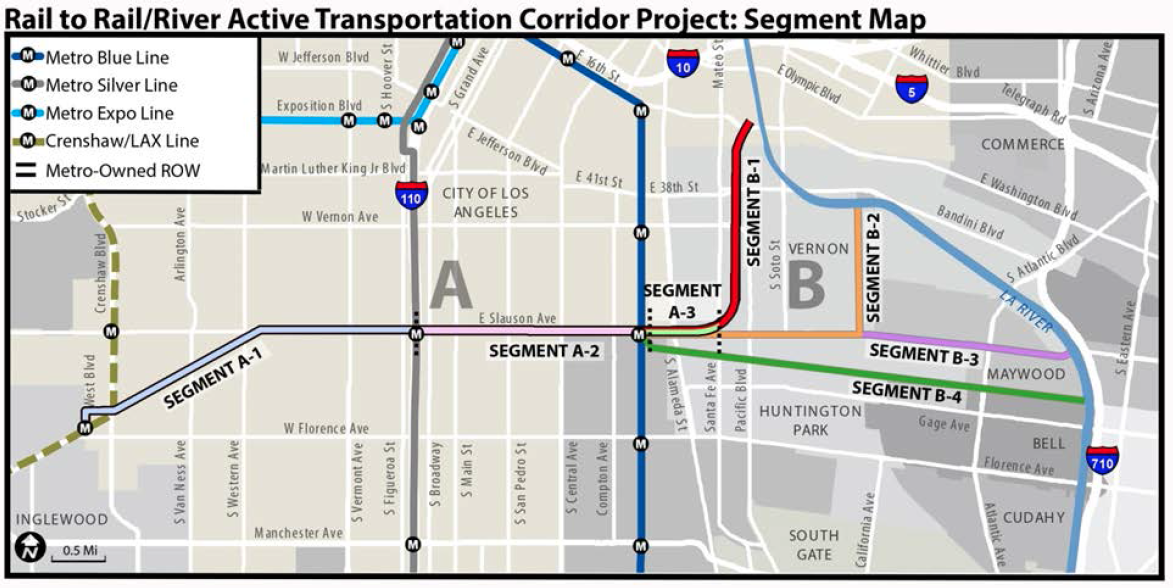
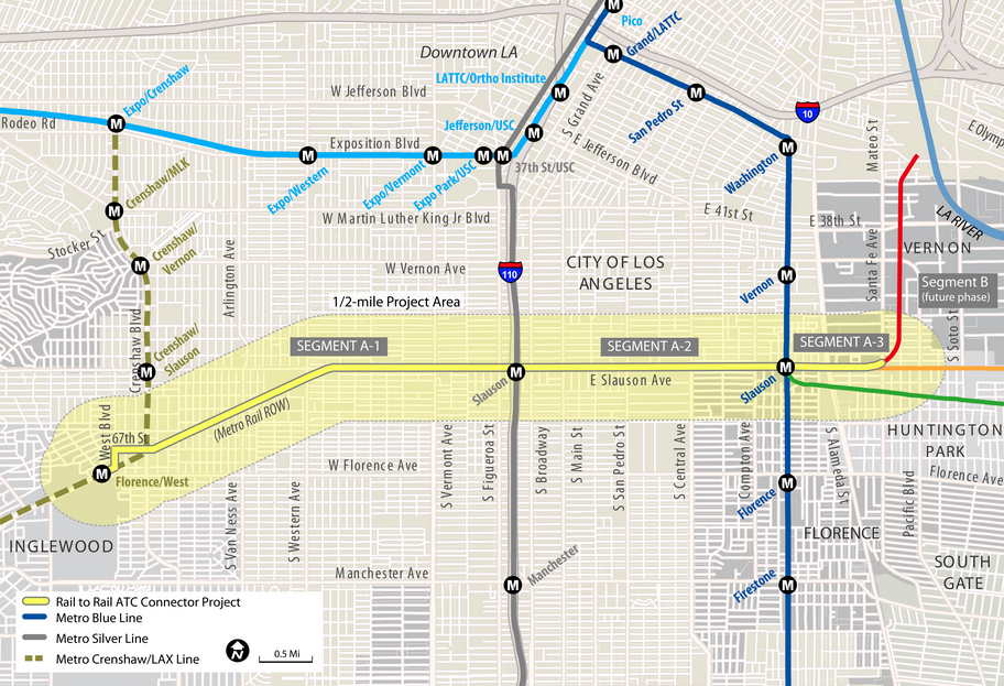
I had reached out to Lopez for feedback after attending Metro's mid-afternoon session on the R2R project held last Wednesday in Huntington Park. The R2R project - a dedicated bike and pedestrian path that will stretch between the Crenshaw and Blue Lines, and to (or through) the Southeast cities to the east - is much-needed in the park-poor and truck-dominated corridors of the communities of South Central and Southeast Los Angeles.
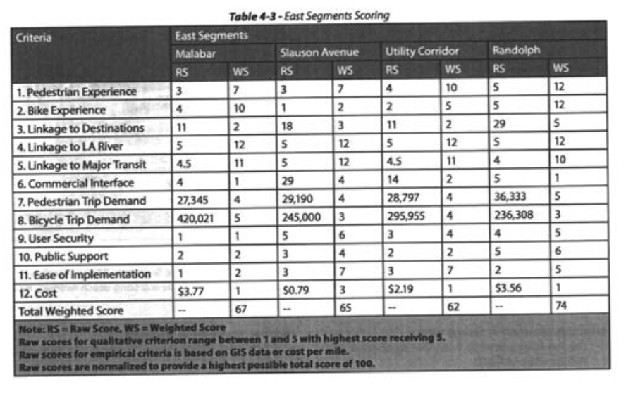
But many of the participants, I realized as we gathered around the tables to decide how to serve Southeast residents' needs best, were not from the area and/or not very familiar with where people worked or how they got there. All of which made speaking to Metro's purpose for the meeting - discussing and ranking the four alternatives for Segment B of the active transportation corridor - somewhat difficult.
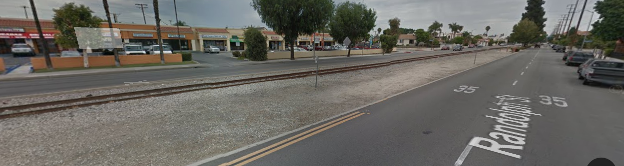
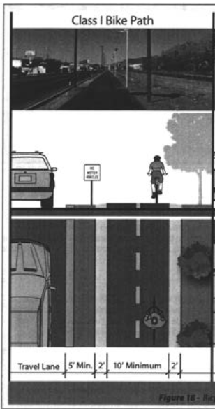
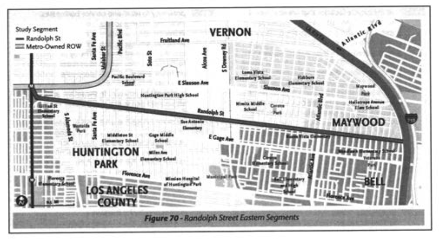
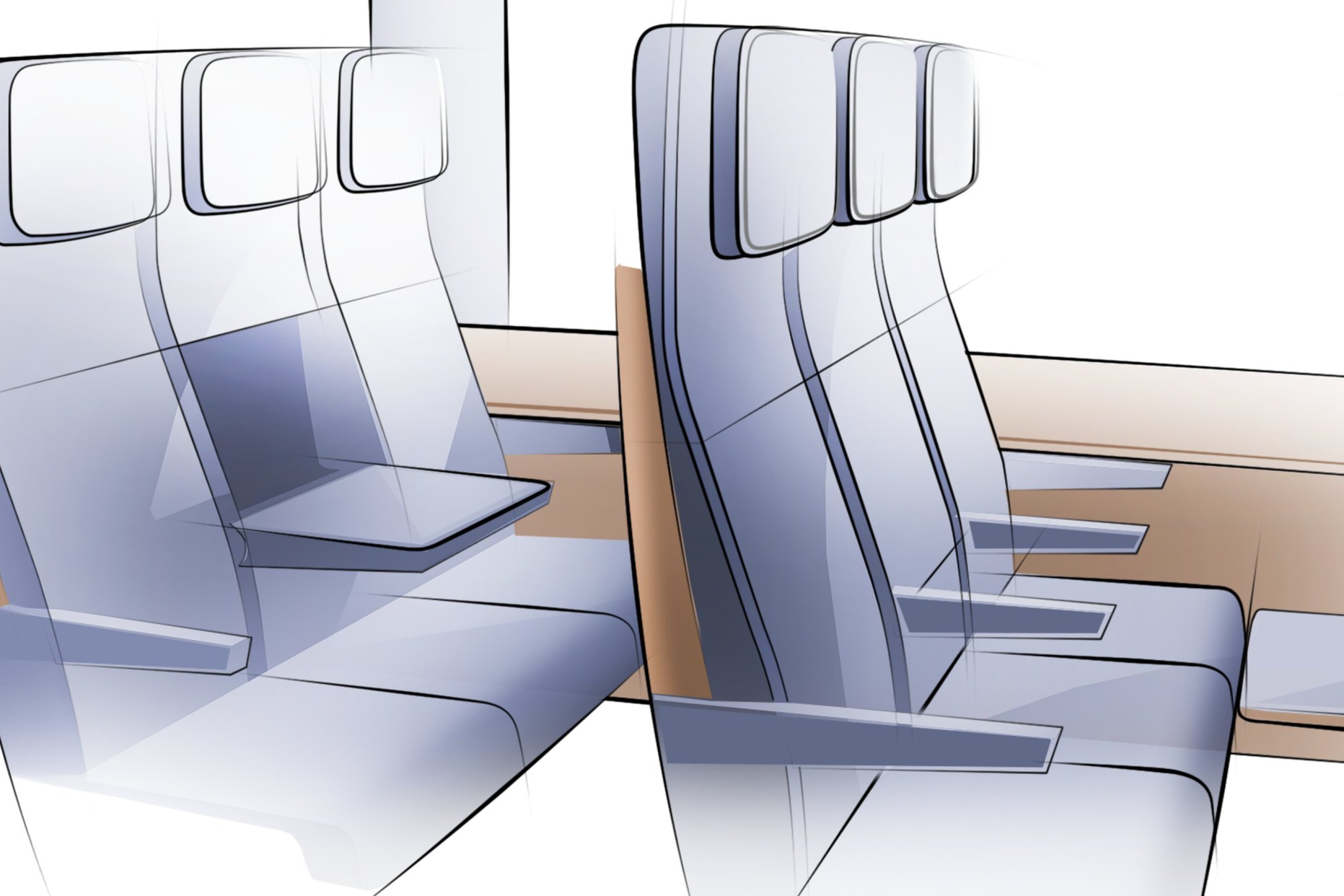
Metro's own 2014 feasibility study had determined that the Randolph Street option should be prioritized. It would not necessarily be the easiest choice - the rail right-of-way (ROW) is owned by Union Pacific, meaning that the cost of acquisition could be quite high and the negotiations involved in acquiring the ROW could take some time. But factors in its favor included the length the route would cover (4.34 miles), user experience, connectivity, safety, transit connections, ease of implementation (see p. 76), and the fact that it would allow cyclists to continue on a dedicated Class I bike path (a separated and protected path, at right). And because the ROW is as wide as 60′ in some sections, it would allow for the inclusion of many or more of the amenities present on the western and central segments of the path.
Users would not have to move back and forth between busy streets and dedicated Class I facilities or lose the bike and pedestrian paths altogether, as they would with the Utility Corridor or Slauson routes. It would also offer users a safe, protected, and lengthy east-west connection through a densely populated and semi-industrial section of Los Angeles usually dominated by heavy traffic and large trucks.
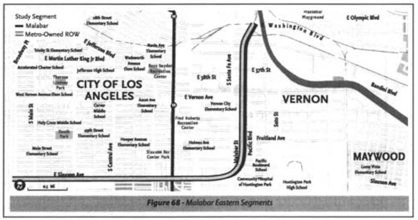
Although, like Randolph Street, the Malabar route would be able to provide users with a dedicated and protected path, it narrows considerably (which would push pedestrians aside) as it makes its way north toward Washington Blvd. It would also move users through less secure industrial areas with fewer connections to transit, residential neighborhoods, commercial corridors, or educational centers. Also, as in the case of Randolph Street, the use of the Malabar Yards ROW would require negotiations with BNSF to get it to abandon its rights to the ROW east of Santa Fe Ave.
All that said, it was still not 100 per cent clear to me which route would better connect residents with their jobs.
A form of demand modeling that summarized the total population and jobs within three miles of the segment and divided that total by the segment length suggested that the Malabar route might serve approximately 100,000 more bicycle trips annually than Randolph Street (below).
A second level of demand modeling that combined population data with utilitarian (school, work, errands, health facilities, transit, etc.), social, and recreational trips forecast Randolph Street would be the most utilized route (below), with as many as 1.6 million bike trips annually.
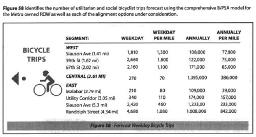
The first model likely captured populations and jobs from Boyle Heights and downtown Los Angeles, boosting the Malabar numbers. The second model captured the many transit, residential, commercial, and other connections one could make along Randolph. But neither offers that much clarity on how well the Malabar option might connect residents to jobs in Vernon or downtown, or how much need there might be for such a connection.
Two representatives from Huntington Park I called over to our table to ask about which route might best serve local commuters weren't really sure, either. It was safe to assume that people in the area traveled all around the region for work, they said.
In the best case scenario, of course, Metro would do both.
It was a suggestion that came up at our table more than once. And although it is probably unreasonable to expect such an outcome, it turns out that, just last month, Huntington Park embarked on its own feasibility study for the same kind of Class I bike facilities along Randolph Street that Metro has already studied.
Meeting attendees were told this when Metro gave its presentation on the project, with the Metro speaker stating somewhat cryptically that Metro fully intended to remain aware of what was happening in Huntington Park. The awkwardness continued when I brought the Huntington Park representatives over to our table. I genuinely wanted their perspective on the routes, but was also curious about how much communication was actually happening. The answer to the latter seemed to be "not very much." Metro representatives appeared genuinely surprised to learn that not only was the West Santa Ana Corridor Eco-Line in the works to link Downey, Cudahy, South Gate, Bell, and Huntington Park, but that the route would also have a stop intersecting with the proposed bike path at Randolph and Pacific.
That Huntington Park is working on its own feasibility study is not that surprising - Metro's own 2014 study noted that the community had just finished its Bicycle Master Plan which included a Class I facility along Randolph.
But the fact that, two years in to such a costly project with such far-reaching potential, each seems to be working in relative isolation doesn't make a lot of sense. I am aware that the relationship between Metro and the Southeast cities is not always one that involves kittens and rainbows. But given that at least half of the Randolph route runs through Huntington Park and gaining access to the ROW (currently owned by Union Pacific) will entail lengthy negotiations and an awful lot of dough, now might be the time to go beyond just being aware of what the other is doing.
Awkwardness aside, the Rail-to-River project continues to move forward.
To that end, Metro will be holding meetings next month to engage community members on the design of Segment A of the project. That 6.4-mile section - running mostly along Slauson Avenue between the Crenshaw Line on the west and Santa Fe (just east of the Blue Line) to the east - is fully funded (above, in yellow) and expected to be completed some time in 2019. We will post those details as soon as they are available. If you have questions or feedback, please direct them to R2R@metro.net or visit Metro's dedicated webpage: metro.net/projects/R2R
We've been covering this project for a few years now. If you'd like to learn more about the development of the project over time, please see any of the following articles:
- December 2013: Dear Santa, Please Bring Us an Active Transportation Corridor Along Slauson, but Don't Forget the Community in the Process (background on the plan; lack of outreach)
- March 2014: Feasibility Study on Rail-to-River Project Takes Another Step Forward (plan begins to come together; outreach still a major problem)
- October 2014: Motion to Move Forward on Rail-to-River Bikeway Project up for Vote Thursday (breaks down the feasibility study in more detail, costs, timeline)
- May 2015: Planning and Programming Committee Recommends Metro Board Take Next Steps on Rail-to-River ATC (more on costs, timelines)
- October 2015: The Rail-to-(Almost)-River Gets Boost with $15Mil TIGER Grant (yay, actual money!)
- May 2016: Metro Awards Contract for Environmental Study and Design of Phase I of Rail-to-River Bike Path (OMG it is actually happening; request that outreach finally be meaningful)
***
The decision to turn the Harbor Subdivision corridor into a (temporary) bike and pedestrian path that preserves the ROW in the event it should become feasible to construct rail there at some future date has been angrily debated in each of the comments sections of previous articles on this project. Should you feel the need to once again vent your anger over the decision to stop holding the community hostage to blight while waiting for rail to become more feasible, I suggest you channel said anger more productively by contacting Metro directly, R2R@metro.net. Thank you.
Stay in touch
Sign up for our free newsletter
More from Streetsblog Los Angeles
This Week In Livable Streets
CicLAvia returns to Venice Boulevard, Metro board committees, L.A. City Council Transportation Committee, Metro budget theater, and more

Measure HLA Is Now Officially Law for L.A. City
Check the city maps to find what bus, bike, and walk improvements are coming to streets in your neighborhood