Changes at CicLAvia: New Route, New Dates
Change is in the air for CicLAvia, the gigantic car-free party that has changed the way Angelenos think about their streets. First, the date for this October's CicLAvia V has been moved forward from the original date of October 14 to October 7. With the city planning to bring a space ship through the streets on the weekend of October 14, CicLAvia obliged the city and space fans by agreeing to move this event to October 7. The streets will open to bicyclists, pedestrians and all non-motorized road users at 10 am and remain open until 3 pm on the 7th. Details of the spaceship's parade route have yet to be announced.
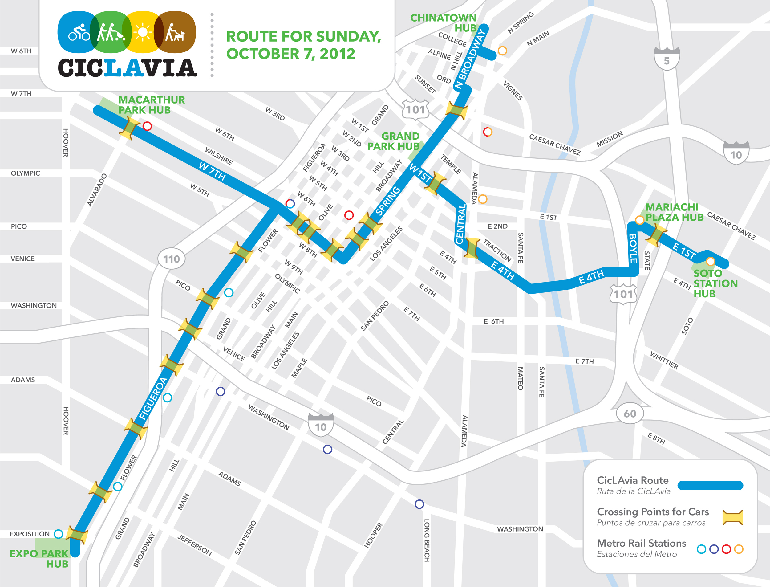
But an even bigger change than the date is the route. The core of the CicLAvia route remains intact on 7th and Spring Street in Downtown Los Angeles, but all of the route's "arms" have changed. Gone are the "starting points" at Hollenbeck Park in East L.A. and the Heliotrope/Melrose "Bike District" in East Hollywood. Instead, the western most point of CicLAvia V is at MacArthur Park in Mid-Town and the eastern most point is Soto Station on the Gold Line.
Aaron Paley is one of the first steering committee members for CicLAvia. In simplest terms, he explains the new route as a "north-south" route with arms going east and west instead of the opposite. He also says the dramatically changed route is the first of many changes that will be coming to CicLAvia in the coming years.
"We don't want to repeat the same route over and over again," Paley explains. "We want to set the precedent that CicLAvia is not set to one area, and not for just the streets we started out with....This is in effect a harbinger of things to come."
The new route is actually a little smaller than the previous two, measuring 9.1 miles. But the new routes and new destinations should provide plenty of new attractions for the cyclists, pedestrians, skateboarders and everyone else who take over the streets.
South L.A. and Exposition Park
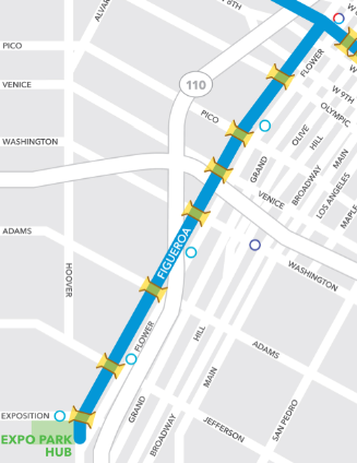
The most dramatic change is the new "South L.A. Spur." At CicLAvia IV last April and CicLAvia III in October 2011, a spur shooting southeast on 9th street took CicLAvia participants from downtown Los Angeles to Central Avenue before stopping at the African American Firefighter Museum. This October, the route heads South on Figueroa Street, on from the famed intersection of "7th and Fig" south past Staples Center and L.A. Live, under the I-10, and past Washington and Adams before stopping near the University of Southern California at Exposition Park.
"We want CicLAvia to make connections between neighborhoods," says Paley. "One of these connections we wanted to make was going south into South L.A."
Community groups have expressed support for extending the route farther south on Central Avenue. The routes from CicLAvia III and IV stopped at the Firefighter Museum on Central Ave., but extending it farther south on that street was harder than it appeared.
"We were on Central with the intent going all the way south past the freeway into the heart of South Los Angeles. We've been thwarted on that front by the train tracks. So we looked somewhere new," explains Paley.
This route down Figueroa provides two opportunities to get more people involved and provide new experiences for Angelenos new to the area. First, the area around USC has the highest concentration of bicyclists than any other part of the city. Getting a greater involvement from these cyclists, and the campus itself would be "fun to tap into," and could create a different feel for CicLAvia.
The second new attractions is Exposition Park itself. As Paley puts it the park is both "well known and unknown" to a lot of Angelenos noting both its iconic reputation and local usage. The park has been a part of Los Angeles since 1872 and in addition to the large parcel of open space and the Coliseum is also home to the California Museum of Science and Industry (Exposition Building), National Armory, Domed National History Museum and the Sunken Garden (which in 1928 was later renamed the Rose Garden).
Last but not least, Exposition Park has its own train station. "We knew the Expo Line was going to open, and that made it all the sweeter," Paley says of the decision to stop the route at Exposition Park. For Westsiders or residents of Culver City, CicLAvia can seem a long way away, especially for occasional cyclists who don't want to risk not getting a place on a bike rack. The Expo Line makes commuting to CicLAvia a much shorter, and easier, proposition.
The new route may look awfully familiar to Streetsblog readers as it mirrors a large portion of the South Figueroa Corridor Project. CicLAvia I on October 10, 2010 heralded the now-popular 7th Street Bike Lanes. Will the CicLAvia South L.A. herald a successfully implemented separated bike lane?
And for those that worry that the new route doesn't take people to the heart of South L.A.? "This is just the start," promises Paley.
East L.A./Boyle Heights
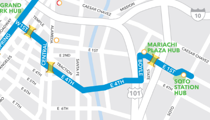
Any Boyle Heights residents disappointed after CicLAvia maps mistakenly showed the route extending Mariachi Plaza last April will be happy to see the route extend not just to Mariachi Plaza but to just past the next Gold Line Station, Soto Station. The new East L.A. route will pass many Boyle Heights cultural landmarks including the famed Mariachi Plaza and local favorites such as the Libros Schmibros used book store and lending library.
However, the new route through some of the cultural spots in East L.A. forced CicLAvia to cut off the original east spur to Hollenbeck Park. This spur had been the only East L.A. spur for the first four CicLAvias. It wasn't a cost issue that moved CicLAvia away from Hollenbeck. CicLAvia's team had always wanted to do something different on the Eastside, but doing both the Hollenbeck route and the 1st Street route proved a practical problem.
"People living between 1st Street and 4th Street would literally be trapped in a couple of block area if they weren't participating," explains Paley. "There would have been CicLAvia on three sides and a freeway on the other."
Chinatown and Grand Park
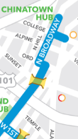
For the past two CicLAvias, participants had the option to shoot north off 1st Street in Downtown Los Angeles past City Hall and then up to El Pueblo. This October, the route continues further into the heart of Chinatown along Broadway. Plans to extend the route this far north for CicLAvia IV were scrapped because organizers of a Chinese New Year parade worried that the parade attendees and CicLAvia participants would be too large a crowd.
Just as the stop at Exposition Park takes CicLAvia farther South than any previous route, the Chinatown spur provides a northern expansion. The distance between the two hubs is almost four miles as the crow flies, providing participants a chance to explore two very different parts of Los Angeles.
Technically, the existing route from CicLAvia III and IV both traveled past what wil be Grand Park, 12-acre park that will stretch from Grand Avenue at the Music Center to Spring Street at City Hall. With the park's opening set for July 28th, CicLAvia will be the first chance many Angelenos have to explore the new swath of open space in Downtown Los Angeles.
Farewell Bike District
The main casualty for the new route is the traditional "start" at the Bike District at the corner of Heliotrope and Melrose. The District, which until recently housed the Bicycle Kitchen, was long considered the hub of Los Angeles' DIY bike culture, and there are few DIY projects as large as CicLAvia. Maybe one day a future CicLAvia will head from Barnsdall Park down Hollywood and Sunset Boulevards towards Downtown Los Angeles, passing just two blocks from the Bike Kitchen's new home just east of Fountain and Virgil Avenues.
Transit Access
With the new spurs to Exposition Park in South L.A. and 1st Street in East L.A., CicLAvia is connecting the event to Los Angeles' growing rail network. Exposition Park is one of the largest light rail stops on the Expo Line and by switching out a route to Hollenbeck Park for a route along 1st Avenue, there are many Gold Line Eastside Extension stops right on the route including the iconic Mariachi Plaza. For those coming south on the Gold Line from Pasadena or Northeast Los Angeles, the Chinatown stop on Spring and College is just one block from the CicLAvia's northern spur into Chinatown.
According to Paley, this isn't a coincidence.
"We want CicLAvia to have an impact beyond the event day," supplies Paley. "A lot of people ride Metro to CicLAvia for the first time. We like that a lot too."
Follow-up
Have questions about the new route? Leave them in the comments section. We'll be doing a question and answer session with Stephen Villavaso and Streetsblog readers next week. Villavaso is a transportation engineer with Skansa and a member of the CicLAvia steering committee. He'll be available to answer all your CicLAvia related questions. Check back on Monday for more details on the Q and A.
Stay in touch
Sign up for our free newsletter
More from Streetsblog Los Angeles
Eyes on the Street: New Lincoln Park Avenue Bike Lanes
The recently installed 1.25-mile long bikeway spans Lincoln Park Avenue, Flora Avenue, and Sierra Street - it's arguably the first new bike facility of the Measure HLA era


Brightline West Breaks Ground on Vegas to SoCal High-Speed Rail
Brightline West will be a 218-mile 186-mile-per-hour rail line from Vegas to Rancho Cucamonga - about 40 miles east of downtown L.A. - expected to open in 2028
This Week In Livable Streets
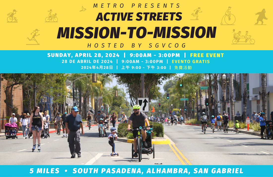
Active Streets Mission-to-Mission, LAPD reports on its use of force in 2023, Pasadena Transit plans, Metro subway construction, and more