Looking into Los Angeles’ 2010 Draft Bike Plan

The new draft 2010 City of Los Angeles Bike Plan was released on Friday June 18th 2010. The draft is available online at labikeplan.org.
That website is also where interested parties can sign-up for bike plan
webinars tonight at 6pm and 7:30pm. At tonight's webinars, the city
will explain the already-released 2010 draft and will release a
new piece: its 5-year implementation strategy.
While the 2010 draft is, in some ways, an improvement over the
disappointing 2009 draft, it's still incomplete and problematic. This
article reviews the bike plan process, then begins to analyze what's in
and what's missing from the 2010 draft, as released so far.
BACKGROUND
The city of Los Angeles' bike facilities and bike policies generally flow from the city's approved 1996 Bicycle Master Plan,
currently in effect. State law requires that the bike plan be approved
every five years for the city to remain eligible for state bicycle
funding, so the 1996 plan was re-approved essentially unchanged in 2002
and 2007, and remains in effect.
In 2007, the city began the process of updating its bicycle master plan. It hired consultants, held meetings, set up a website.
Last year, in May and September, the city released different versions
of its 2009 Draft Bike Plan. Though it had a few promising aspects, the plan met with a great deal of criticism. At Streetsblog, Stephen Box wrote that it lacked vision, substance and teeth, and this author called it non-committal and sloppy. The L.A. County Bicycle Coalition and C.I.C.L.E. joined forces to campaign for a better plan, with some focus on the lack of bike lanes. Where the 2009 draft plan stated that it contained 125 miles of new bike lane, lists and maps only showed 28 miles.
THE 2010 DRAFT
The 2010 draft bike plan as initially released remains fairly sloppy
and non-committal. The 2010 draft includes a lot of numeric assertions.
The cover boldly states "1633 miles" of bikeways. This compares to a
stated existing total of "approximately 339 miles" of existing
bikeways, which break down into "58 miles of bicycle paths, 157 miles of
of bicycle lanes, and 124 miles of bicycle routes." (all Chapter 3,
Page 40)
The 2o1o draft shows new facilities broken out into two networks: the
Citywide Bikeway Network (CBN) and the Neighborhood Bikeway Network
(NBN). The CBN is pretty clearly based on the L.A. Bicycle Working Group's Backbone Bikeway Network. The NBN is mostly the bike-friendly streets carried forward from the 2009 draft.
The plan shows various total mileage. The CBN is 660 miles long, the
NBN is 672 miles long - so the two total 1332 miles... which leaves 301
miles unaccounted for in the 2010 draft 1633 miles. This author refers
to these extra 301 miles as the Remainder Bikeway Network (RBN.)
Unfortunately, the plan contains no listings of what facilities
belong to each network, hence there's no way to tell exactly what counts
toward what totals. The only way to discern this is to read the maps.
Unfortunately, there are quite a few errors on the maps, and many
discrepancies between various different versions of maps showing the
same area, and quite a few streets and facilities not clear and/or not
labeled. When facilities from the maps are totaled, they don't add up to
the totals in the text. With all these errors and discrepancies, it's
very difficult to tell the actual extent of what's actually planned, and
whether it's worth supporting.
ERRORS ON 2010 DRAFT MAPS
The maps are the substance of the facility plan in the absence of any
facility listings. They include plenty of errors. For example, here's a
detail of the map of existing bike facilities in the south east portion
of the San Fernando Valley:

The above map detail shows two existing bike paths (solid green
lines): one path on the Orange Line right-of-way from Coldwater Canyon
Avenue to Lankershim Boulevard and another path on the Los Angeles River
extending from Woodman Avenue to Colfax Avenue in the east San Fernando
Valley. Neither of these bike paths exist in the locations shown.
The same Existing Bikeways map shows non-existant bike lanes
(including lanes on Vermont Avenue from 135th Street to Gardena Blvd),
and other missing and erroneous paths, lanes, and routes.
DISCREPANCIES BETWEEN VARIOUS 2010 DRAFT MAPS
There are also differences between the maps. Here are two maps, both
from the 2010 draft, showing the Sunland area in the northeast San
Fernando Valley:

The map on the left above shows the CBN (purple) and the NBN (gold.)
The map on the right shows all the facilities in the plan: CBN, NBN, and
RBN, with bike paths (green), bike lanes (red) and bike friendly
streets (light blue.) Theoretically, the map on the right is supposed to
include all the bikeways on the left map, possibly with some additional
ones. The map on the left shows the vertical line between the words
Peoria and Sunland (which is more-or-less part Stonehurst Avenue and
part Clybourne Avenue, unlabeled) connecting to Sunland Boulevard. That
network bikeway should be explained on the right map... but it's
missing. Which map will be used to implement these facilities?
The plot thickens when one compares these current maps to the 2010
draft maps originally released on June 18th, and even what actually
exists on the ground. Here's the same Sunland area as mapped above:

The city has been updating its 2010 draft maps since the June 18th
release, without notice or any explanation of what has changed, and
without leaving prior versions available on-line. New maps appeared on
the labikeplan.org
website, indicating that they had been updated June 25th, with no
explanation of what had changed. The analysis for this article began
with the June 18th map version shown above left, which has been
since updated.
When comparing these conflicting versions to the existing
on-the-ground conditions, the Network map connections become even less
clear. From the Google aerial map, it turns out that there's no road
connecting Clybourne with Sunland... so perhaps the city is planning a
bike path there? a new road? Impossible to tell from the 2010 draft.
This discrepancy is one among many. The 2010 draft maps don't match
each other, so it's difficult to tell what bikeways are planned.
MAPPING BIKE LANE MILEAGE
Bike path mileage and bike-friendly street mileage will tend to be
limited by available funding. It's important that these facilities
are in the plan, but the number of miles of these facilities will
generally be limited by the city's ability to obtain outside funding,
mostly through the Metro Call for Projects.
On-street bike lanes are very cheap, so the plan's total bike lane
mileage is a barometer of the city's political will to commit street
space to bicycles.
The text of the 2010 draft continues the unfortunate distinction
between "proposed" bike lanes and "potential" bike lanes - as found in
the 2009 draft plan, but not in the current city plan. Earlier in 2009,
the lanes labeled "potential" were labeled "infeasible," which, though
disheartening, was at least truth-in-advertising.
The 2010 draft states that potential lanes are "considered
speculative." (Chapter 5, Page 94.) It seems pretty clear that, unless
there's a major pardigm shift in the way that the city approaches its
streets, approximately none of these "potential lanes" will actually be
implemented. "Potential" likely means "never." This author hopes that
this proves untrue. Perhaps the city will show its commitment by
including plenty of the "potential" lane facilities of the city's
5-Year Implementation Strategy to be released later today.
Given the "speculative" nature of the "potential" lanes, much of the
substance of the plan is shown in the city's commitment (or lack
thereof) to "proposed" bike lanes. The initial June 18th 2010 draft
stated total mileage for "proposed" bike lanes, but included no listing
nor mapping of where the "proposed" lanes were; all the maps
merely lumped together "proposed" and "potential."
Subsequently, on June 25th, the city released (unannounced,
unnoticed) additional "Bikeways Engineering" maps, which show which
lanes are "proposed" vs. "potential."
The 2010 draft (Chapter 3, Page 41) states that the plan contains 56
miles of "proposed" bike lanes. Based on total mileage shown on the map,
totaled by the author with the assistance of Ramon Martinez and Stephen
Villavaso, the maps show only 46.65 miles of new bike lanes. See totals on spreadsheet here.
So, the 2010 plan states that it has 56 miles of bike lane, but only
maps 46 miles of those. This discrepancy is sloppy and deceptive, but it
actually compares favorably with the 2009 draft, which stated it had
125 miles, but only mapped/listed 28 miles. These both compare
unfavorably with the existing 1996 plan, which designates 190 miles of
future bike lane. There's very little reason for bicyclists to support
the new 2010 draft when it scales back the city's commitment to new bike
lanes from 190 miles, already approved, to only 46 miles.
The 10-mile discrepancy between the plan's stated total and the
actual facilities mapped throws the prominent "1633 miles" of bikeways
number into doubt. This author did not have time add up all the miles in
the plan, but from the bike lane mileages exaggerations, it's unlikely
that the 1633 number could be correct. But the public will never know
until the city actually releases the list of facilities that they used
to arrive at their 1633 total.
NEXT STEPS FOR THE BIKE PLAN
If the city expects bicyclists to support a new plan, it should have
at least as many bike lane miles as the existing plan. There are
190 miles of approved designated new bike lanes remaining on the current
plan. If the new plan commits to only a small fraction of these 190
miles, then bicyclists should just support keeping the existing plan in
place.
In both 2009 and 2010 drafts, the stated bikeway mileage totals are
exaggerations. The 2010 draft lacks transparency by publishing mileage
totals with no corresponding listings of the facilities mileage that
were totaled. Were these totals done on the back of a napkin, then
discarded? If the city is serious about getting public input on its 2010
draft plan, and building support for the plan's passage, then it needs
to publish the lists of planned bikeways facilities, not just as lines
on maps.
The 2010 draft text and maps released so far contain many errors and
inconsistencies. The city needs to proofread and publish a new draft
with clear accurate maps, totals, and texts.
There remains a lot of potential for good things to come out of this
Bicycle Master Plan update. It will be a sad day if the city's
sloppiness, lack of transparency, and backpedaling result in good
elements of this plan being discarded due to its faults. It's only a
draft, there are still additional draft documents being released,
and further rounds of public input. Perhaps the city's planners will
arrive at an improved next iteration of the 2010 draft. The jury is
still out.
Stay in touch
Sign up for our free newsletter
More from Streetsblog Los Angeles
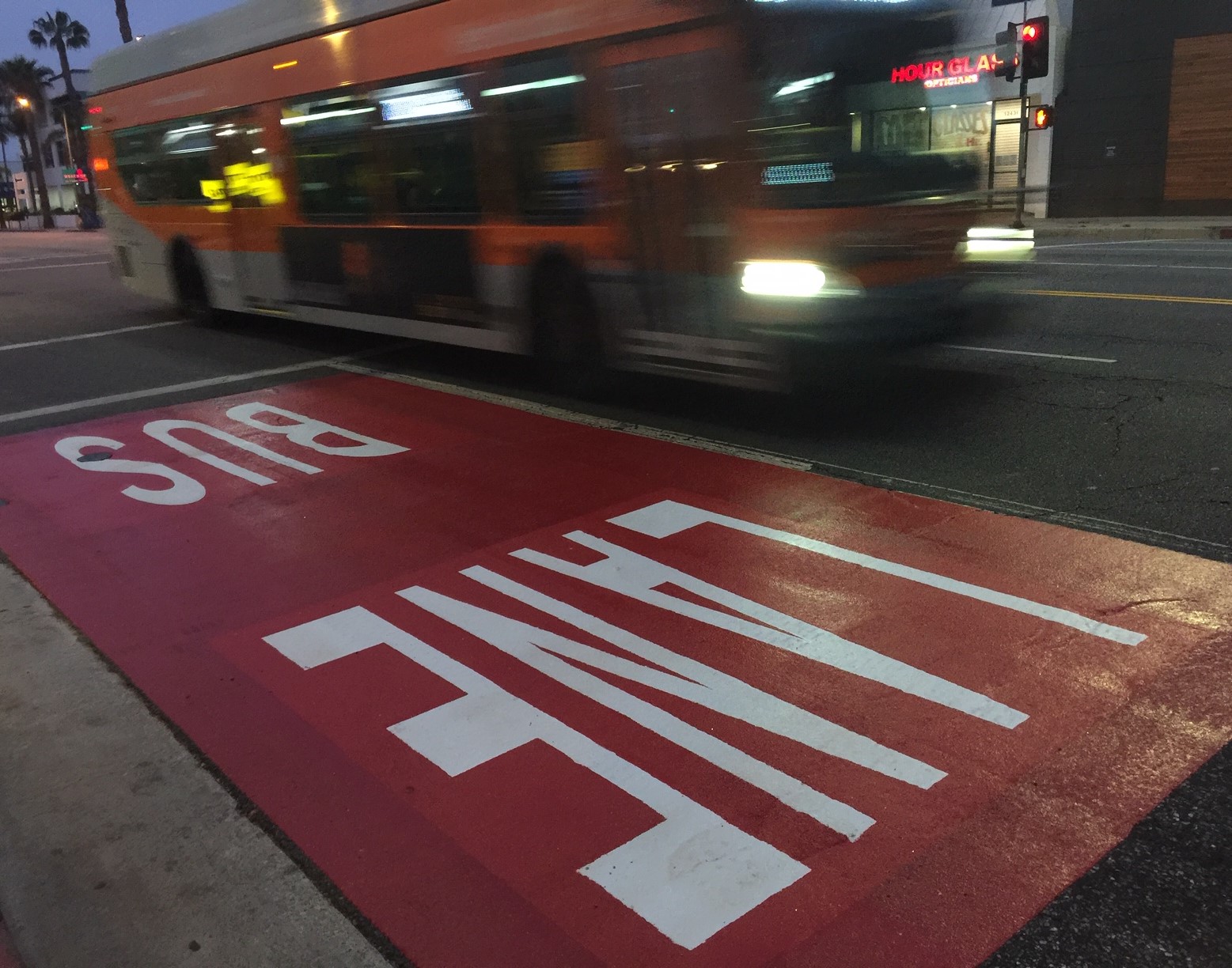
Automated Enforcement Coming Soon to a Bus Lane Near You
Metro is already installing on-bus cameras. Soon comes testing, outreach, then warning tickets. Wilshire/5th/6th and La Brea will be the first bus routes in the bus lane enforcement program.


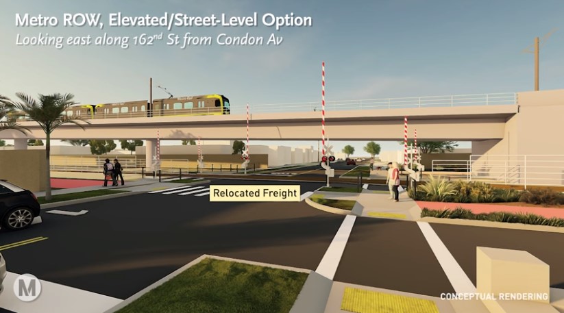
Metro Looks to Approve Torrance C Line Extension Alignment
Selecting the relatively low-cost hybrid alternative should help the oft-delayed South Bay C Line extension move a step closer to reality